
History
The parish community of Newbridge and Ballymaguigan forms part of the large parish of Ardtrea (officially Artrea) which consists of forty-eight townlands, thirty of which are in Co. Derry and eighteen of which lie a short distance to the south-west in Co. Tyrone. The name is first recorded in the "Charter of Londonderry and Plantation” documents dating from 1602 -1670 but the its origins lie far back in time.
Ardtrea (from the Irish Ard Tre, meaning " Trea’s height or hill”) takes its name from the fifth century saint, Trea who is the patron saint of the parish and after whom our church is named. She is said to have been a sister of Saint Lurach of Maghera and her feast day is celebrated on 3rd August. The story of St Trea is found in the ninth century Tripartite Life of St Patrick:
"St Patrick crossed the Bann at Toome and entered the kingdom of Ui Thuirtre which, at the time, was ruled by a king named Cairtheann Mor. The latter ordered him out of the kingdom and the saint responded by taking the kingdom away from him and his offspring and bestowing it on his brother Cairtheann Beag who had been exiled as a result of a dispute. The saint baptised Cairtheann Beag and blessed his wife and child who lay in her womb promising that the child would be full of grace and that he would place a veil on her head".
(Triipartite Life I page 168)
The child in the womb was none other than St Trea and St Patrick's prediction that he would place a veil on her head was later fulfilled when she became a nun.
At the time of the Plantation the stretch of the north-western shore of Lough Neagh from the mouth of the Ballinderry River to Ballymaguigan was known as Killetra (from the Irish, Coill Iochtarach meaning "Lower Wood”) and the territory formed part of a much wider wooded area said originally to have stretched to Coleraine. The Irish origins of other placenames in and around our parish give an interesting insight into the history of the area and many of the characteristics they describe are still here today:
· Annahorish/Anahorish (from the Irish Eanach Fheorais meaning "marsh of the grassy river bank”): in 1972, Seamus Heaney translated it as his "place of clear water” in the poem, "Anahorish”...
· Aughrim (from the Irish, Eachroim meaning "Horse Ridge” ): Aughrim Hill rises to 40m and is described in the Ordnance Survey Revision Book of 1858 as an "oval shaped cultivated hill” formerly known as Aughrim Thorn, from an old thorn bush that grew near the summit.
· Ballymaguigan (from the Irish, Baile Mhic Guaigin meaning "McGuigan’s townland”): the name of the townland is recorded as Ballemcquiggin in a grant from King James I to Sir Thomas Phillips in 1612. In the north-west of the townland is the village of Gracefield which was founded by the Moravians in 1749, when the church (now a Church of Ireland church), clergyman’s residence and preacher’s house were built.
· Derrygarve: (from the Irish Doire Garbh translated roughly as "rough oak wood”): is recorded as Derrygarraff in the 1613 "Charter of Londonderry”.
· Drumenagh (from the Irish An Droim Meanach meaning " the Middle Ridge”): droim (the ridge) appears to refer to Drumenagh Hill which rises to 50m and on the summit of which are the remains of a rath. This is sometimes referred to locally as the fort. A rath is usually a circular earthwork which would have served as a stronghold and residence of an ancient Irish chief.
· Newbridge is named from a bridge with three arches which was built c 1806 across the Moyola river linking the townlands of Derrygarve and the Creagh (Etre and Otre). Newbridge is translated into Irish as Droichead Nua.
· Moyola: the river flows from the Sperrins seven miles south-west of Draperstown to where it flows into Lough Neagh at the Near Waterfoot in Ballymaguigan. The original Irish name of the river was Bior, a word meaning simply "water”. The name "Moyola” which apparently comes from the Irish, Maigh Fhoghlach meaning "plain of the plundering,” originally only applied to the final course of the river as it runs through the Creagh but was later transferred to the river as a whole.
· The Creagh (Etre and Otre): (from the Irish, An Creach meaning "the coarse pasture”): was referred to in 1659 as the 2 townes of Moyola. It was formerly divided into two portions and this division is reflected in today’s Etre ( in Irish: Iochtarach meaning "lower”) and Otre ( in Irish: Uachtarach meaning "upper”).
· Traad Point: (from the Irish An Tra Fhada meaning "the long strand”): a popular swimming place in days gone by.
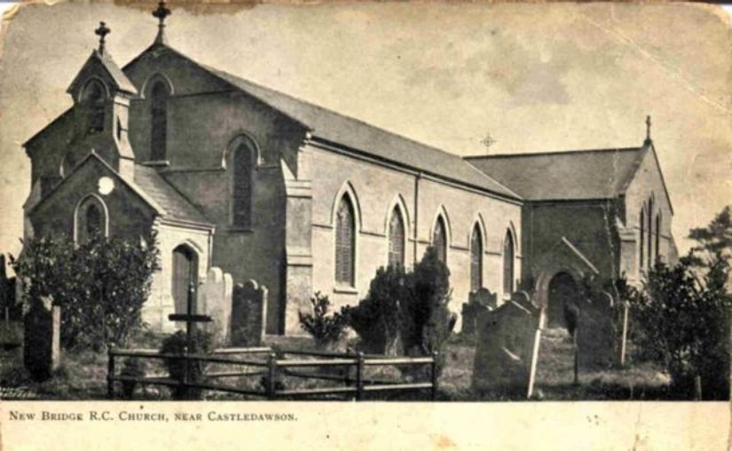
The Church of St Trea
The earliest written record of a church on the current site dates from the Ordnance Survey (OS) of 1830 which records that:
"The RC chapel is situated in the townland of Derrygarve on the road leading from Magherafelt to Toome. It is a clumsy building 74 feet long and 26 feet wide fitted with a gallery and containing accommodation for 450 people. It was built by subscription in 1813".
The OS describes the three RC chapels in the parish of Ardtrea as "clumsy buildings", not a description it gives to other churches. So it probably reflects more on the perspective of the surveyors rather than the condition of the church. It’s worth remembering that the penal laws which restricted catholic worship only became nullified by the Roman Catholic Relief Act (1791) and Catholic Emancipation wasn’t achieved until 1829. To have gathered enough subscriptions to construct such a building in 1813, pre-famine Ireland demonstrates a level of commitment and determination on the part of our ancestors of which we can be proud.
St Trea's appears again in Griffith’s Valuation of Ireland in 1858. Richard Griffith was a surveyor who was sent to conduct a valuation of every piece of agricultural or built property on the island of Ireland and it was published on a county-by county basis between the years of 1847 and 1864. The valuation shows an "RC chapel and graveyard” occupying a total of 2 acres at its current location. The current church building is the result of a refurbishment in the 1890s. It remains the heart of our parish to the present day.
You can find more about Griffith’s valuation by using the link below. It allows you to search for family names by county (in the case of our parish, you select "Londonderry”). To search using Step 2 (which is optional) select the option called "Loughinsholin” (in the box called "Barony”) and "Artrea” (in the box called "Parish”). From there you can either view the register themselves or the maps that go with them.
http://www.askaboutireland.ie/griffith-valuation/